Climate Map:
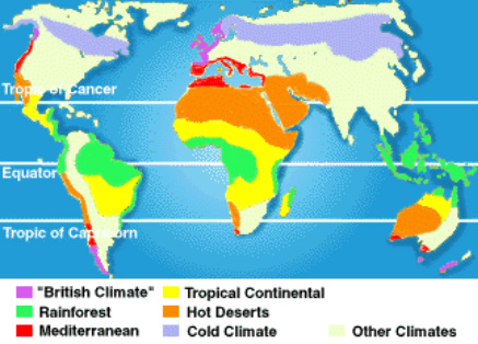
The Hot Deserts of the world can be seen in the orange colour on this climate map.
- Dry Tropical Climate (BW) desert biome. These hot desert climates can be found in low-latitudes that are between 18° to 28° in both the Northern and Southern hemispheres. These latitude belts are on the tropics of Cancer and Capricorn, that are just north and south of the equator. They coincide with the trade winds. Winds are light, so this allows the evaporation of moisture in the intense heat to happen. They usually flow downwards so the area is generally not penetrated by air masses that form rain. This gives a very dry heat. The dry arid desert is a desert climate, and covers 12 % of the Earth's land surface. Dry deserts are also usually found on the western side of the land masses that are near cold ocean currents! The Hot Deserts of the world include:
- The Sahara Desert (North Africa)
- The Kalahari and Namib Deserts (Botswana, Namibia, and South Africa)
- The Australian Deserts (covering 70% of Australia)
- The Arabian Desert (Egypt)
- The Atacama Desert (Coast of Chile, South America)
- And The Southern California Desert!(South California)
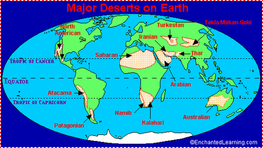
Major Deserts on Earth:
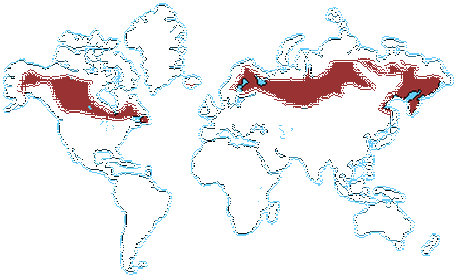
Boreal Climates
The Boreal climate type can be seen in the grey colour on the climate map!
Taiga is the Russian word for forest and it is one of the largest biomes in the world. It stretches over Eurasia and North America. The taiga is located near the top of the world, just below the tundra biome. The winters in the taiga are very cold with only snowfall. The summers are warm, rainy, and humid. A lot of coniferous trees grow in the taiga. The taiga is also known as the boreal forest. Did you know that Boreal was the Greek goddess of the North Wind?
The Boreal Climate stretches across the Northern Hemisphere between 50 degrees North and the Arctic Circle.
The Boreal Climate stretches across the Northern Hemisphere between 50 degrees North and the Arctic Circle.